Overview

Allvision solves some of the world’s most pressing problems by helping businesses use spatial maps to understand dynamic environments. CloudFactory makes that work possible through a flexible partnership and by delivering with speed and quality.

Services Used

  • Computer Vision Managed Workforce

Read the client story that follows, or download a PDF version you can reference later.

industry

Industry

Aerial and Spatial

headquarters

Headquarters

Pittsburgh, USA

company size

Company Size

0-50

8x

faster in achieving their mission

5 million

images processed (and counting)

4+ years

flexible partnership

Meet Our Client

Allvision, a U.S.-based spatial data and analytics company, brings complex maps to life to give businesses, cities, and governments street-level visibility of their environments plus analytics on those environments at scale.

The startup’s core product is AIGIS, or AI for GIS (geographic information system), a platform that aggregates and processes multimodal LiDAR, image, video, and trajectory data from ground-based mobile sensors. It uses robotic sensing technology, machine learning, and the power of cloud computing to create high-value information products and richly detailed, complex maps.

Allvision’s customers use the SaaS platform for applications in transportation, 5G cellular networks, and smart city infrastructure asset management to gain efficiencies, improve sustainability, and make informed decisions in near real-time with maximum confidence.

Their Challenge

Like many startups, Allvision began with a huge dream: To empower smart cities, transportation, and 5G mobile infrastructure with fast, reliable, and accurate data.

They imagined the data would be available through maps so complex and detailed that a government official working on a city safety campaign could zoom in to find out how many bus stops are accessible or how many signs need repairing. Citizens in this city needing accessible bus stops would know that their elected officials were listening and acting on their behalf. The city would be for humans, built by governments and companies that care about the human experience.

That’s Allvision's ambition—to enable governments, startups, and other organizations to see, learn from, and understand complex physical environments. The unique insights AIGIS delivers augment human inspection and physical infrastructure auditing, allowing for cost-effective, preemptive maintenance at an unprecedented scale—work that requires a substantial volume of training data.

The Allvision team knew they couldn’t handle all the labeling work themselves. They needed an expert-level managed workforce with people as passionate about the mission as they were. The workforce needed to be able to scale its capacity, and be available during the hours Allvision needed.

Enter CloudFactory.

The team we originally met at CloudFactory before we started our partnership were passionate and compelling; they went out of their way to understand our place in the market and our mission. Once on-boarded the energy we saw when we kicked off remained bright for the whole of our 4+ years together.

Ryan-Frenz

Ryan Frenz

Head of Engineering and Co-Founder, Allvision

Allvision-ambitious-smart-city-GTM

Our Solution

Allvision chose to blaze trails with us because our first priority was to understand the team’s multi-layered ambitions.

“The team we originally met at CloudFactory was passionate and compelling; they went out of their way to understand our place in the market and our mission,” says Ryan Frenz, Allvision’s head of engineering and co-founder.

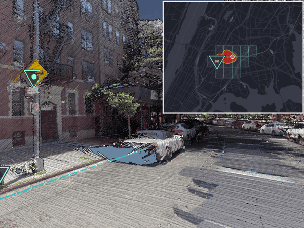
In the earliest phases of the work, our data analysts helped to bootstrap Allvision's core AI-based systems by iteratively labeling key features across a variety of sensor modes, environments, and object types.

Analysts then reviewed and re-reviewed outputs to enable Allvision to reinforce and tune core models before creating digital twins. This continual feedback loop, having now circulated more than 5 million images, allows Allvision to create broad, accurate models at unprecedented speed.

“Every day, CloudFactory is reinforcing the output of our system—making it better, constantly,” says Frenz.

And because Allvision uses transfer learning technology, the team can quickly retune core models to find new objects, making it possible for each subsequent model to be highly tuned to its environment, such as urban core or railroad. This ability to retune models and transfer learning allows AIGIS to serve even more customers and use cases.

The Results

CloudFactory quickly earned trust and proved to be a reliable, high-quality workforce. Our fast time to value meant Allvision’s team was free to focus on critical customer conversations and their GTM strategy.

In our first year working together, we advanced Allvision’s steps toward completing its mission eightfold—a reflection of Allvision’s growth in hiring eight new team members to complete their core GTM work eight times faster. And in the four years (and counting) of our relationship, our data analysts have processed more than 5 million images—images Allvision’s team members didn’t have to label, leaving them free to propel AIGIS into the markets that need it.

Allvision now provides its AI platform capabilities as a service to cities, municipalities, civic organizations, railways, and enterprises that streamline and automate the extraction and processing of GIS information from ground-based mobile mapping systems.

“We’ve built our core capability with CloudFactory and we are so energized by how we will together impact the human experience of environments for the better,” says Frenz. “Once on-boarded, the energy we saw from CloudFactory when we kicked off remained bright for the whole of our four-plus years together.”

The Allvision team is an inspiration to the #AIforgood movement. We at CloudFactory are proud to be part of their mission.

Recommended Reading

Managed Workforce Solutions for the Aerial and Geospatial Industry

We process complex image data for aerial, UAV, and geospatial AI applications—quickly, accurately, and cost-effectively.

Nearmap | Roof Geometry

Our near real-time data labeling for Nearmap helped scale their roof geometry business 4x and deliver quality outputs.

Tired of Data Prep? How to Scale Precision Agriculture Insights with High-Quality Data

Discover safer, faster, lower-cost, and innovative ways of working, plus scalable, sustainable data prep and labeling.

Contact Sales

Fill out this form to speak to our team about how CloudFactory can help you reach your goals.