Overview

Sylvera turned to CloudFactory to help them enhance their carbon sink assessment solution. The CloudFactory team performs semantic segmentation on satellite images to identify the location of mangroves.

Services Used

  • Computer Vision Managed Workforce

Read the client story that follows, or download a PDF version you can reference later.

industry

Industry

Climate Tech

headquarters

Headquarters

London, UK

company size

Company Size

11-50

15,000+

Square Miles of Annotation

500+

Hours Saved

Meet Our Client

Before launching Sylvera in 2020, COO and Cofounder Samuel Gill worked at a U.S. law firm and saw how complicated carbon-offsetting projects could be, and how difficult it can be to get up-to-date data on the climate impacts they promised.

To address this issue, Gill partnered with CEO and Cofounder Dr. Allister Furey, a machine learning expert, to establish Sylvera.

The startup ranks carbon projects, bringing a new layer of transparency to this market by assigning ratings to projects (similar to what S&P Global Ratings and Moody’s do for debt issuances). Companies wanting to purchase offsets to lower their carbon footprints can access rankings and monitoring services via Sylvera’s web app to choose the right project for them and track projects’ performance over time.

Their Challenge

Taking on the gargantuan task of assessing carbon sinks (natural environments that absorb carbon dioxide from the atmosphere), Sylvera needed to accurately verify the performance of the projects they rate. Is a specific forest being preserved as anticipated? Are trees being planted as promised?

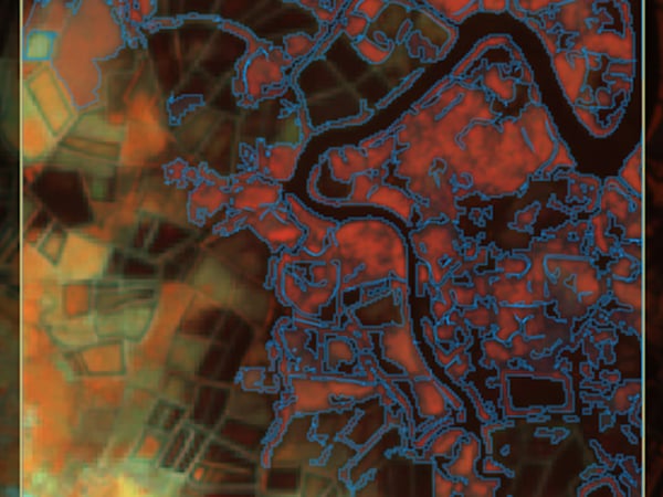
Answering these questions requires precise tracking of land use and its evolution over time. Specifically, Sylvera wanted to track mangroves, which are groups of tropical trees that thrive in salty, coastal conditions. Because they play such a crucial role—soaking up more carbon than regular tropical forests—it’s important that they’re protected.

“Typically, mangroves will sink four times the amount of carbon than a tropical forest would,” explains Sylvera Machine Learning Engineer Virginie Bonnefond. “They need to be protected, so we wanted to track mangroves with artificial intelligence and satellite images. To do this, we knew we needed to train our models, which required millions of images. Instead of relying on public datasets, which cannot provide the spatial granularity we were looking for, we needed to go in and get the data. This is why we started looking for annotators to help.”

Sylvera knew that bringing in students and interns was one option to get the job done, but the company also knew how much additional interviewing, hiring, onboarding, training, and management that approach would take.

In two months, we've labeled an area nearly 25 times larger than London. It would have taken me 500 hours to annotate that dataset. If you need a customized solution, go for CloudFactory.

Virginie Bonnefond

Sylvera Machine Learning Engineer

sylvera

Our Solution

As Bonnefond and her team started searching for solutions, they discovered that many annotation platforms were built for autonomous vehicles. “We need to overlay Google Maps, and we need to constantly shift between different satellite images, including high-resolution imagery from Google Earth, and the tool to understand what’s going on,” she explains. “Those platforms wouldn’t work for us. We needed something more customized.”

She also appreciated that CloudFactory annotators are specifically trained to handle these types of geospatial tasks. “They have a dedicated team. We knew that, once they got over the learning curve, the team would smash the task. In other companies, annotators are much more random. Since this task is slightly different than normal, we don’t want to take that learning curve again and again with new annotators.” CloudFactory was also able to integrate Azavea’s GroundWork tool to meet Sylvera’s labeling requirements.

Because nearly one-quarter of the world’s mangroves are located in Indonesia, Sylvera opted to start by tracking the tropical trees in Southeast Asia. The CloudFactory team uses images provided by Sylvera to form annotation data that explains exactly where mangroves sit. The goal, says Bonnefond, is to ultimately train a deep learning model to help them track losses and gains in mangroves over time.

The Results

In just two months, CloudFactory and Sylvera have worked together to annotate an area that’s nearly 25 times larger than London.

“It would have taken me 500 hours to annotate that dataset,” says Bonnefond. “If we did the work in-house, it would have been done by me or supervised by me, so it would’ve required a machine learning engineer or geospatial data analyst and an army of students.”

She says the entire process has gone smoothly, with clear communication and check-ins along the way. “If you need a customized solution, go for CloudFactory,” says Bonnefond. “I’ve been building some models out of the mangroves classification, and it’s doing great—sometimes doing better than the ground truth itself, managing to correct the approximation from time to time.”

Recommended Reading

We have 10+ years of experience helping our clients focus on what matters most. See what we can do to help your business.

Partnering on Quality Training Data and Social Impact

Azavea interviewed a handful of leading data labeling firms, and studiously compared their pricing, approach, and cultural values. Learn why CloudFactory stood out.

Geckomatics

Geckomatics turned to CloudFactory to help scale their cost-effective solution to more customers around the world.

Geospatial Applications

Geospatial data analysis provides organizations with actionable intelligence about the visual world.

Contact Sales

Fill out this form to speak to our team about how CloudFactory can help you reach your goals.